Join our early access program and receive free access →
Join our early access program and receive free access →
Back to Blogs
Sara
January 3, 2026
19 min read
Understanding what you can build, where you can build it, and how to get started
Whether you’re a homeowner planning an addition, an entrepreneur opening a business, or a developer starting a new project, one question looms large: Do I need a permit for this?
The answer is often yes, but understanding which permit and why can feel like navigating a maze of regulations, codes, and municipal jargon. This guide breaks down everything you need to know about permits, with a special focus on zoning permits: what they are, why they matter, and how modern technology is transforming the process.
Permits are official approvals from local government that authorize specific activities on your property. Think of them as your city’s way of ensuring that development is safe, appropriate for the location, and will not negatively impact your neighbors or community.
At the most basic level, permits serve three critical purposes:
Without permits, we would see oil refineries next to elementary schools, buildings that collapse under normal conditions, and neighborhoods transformed overnight without community input.
Not all permits are created equal. Different types of work require different types of approvals. Here are the main categories:
What they regulate: The structural and safety aspects of construction, ensuring your building will not fall down.
Building permits focus on technical specifications: foundation strength, electrical wiring, plumbing systems, fire safety, and structural integrity. The Building Code ensures structures are built to appropriate standards and are safe for their intended use.
Common examples:
What they regulate: Specific building systems.
These specialized permits ensure that your water heater, electrical panel, or HVAC system meets safety codes and is properly installed.
Common examples:
What they regulate: Work in public spaces and infrastructure.
These permits govern modifications to public property like streets, sidewalks, curbs, and utilities.
Common examples:
What they regulate: Commercial operations.
While not technically a “permit,” business licenses are required to legally operate a business in most cities and ensure businesses comply with local regulations.
And then there are zoning permits, perhaps the most important but least understood category. Let’s explore these in depth.
A zoning permit confirms that your proposed use or development is allowed under the city’s zoning regulations for that specific location.
Here’s the key distinction: while a building permit ensures your structure is safe, a zoning permit ensures your project is appropriate for where you want to build it.
These two codes regulate different aspects of development:
Zoning Code answers questions like:
Building Code answers questions like:
Think of it this way: Zoning ensures your project fits into the community puzzle, while building codes ensure each puzzle piece is structurally sound.
Zoning permits come in several forms, depending on the complexity of your project:
What it is: The most straightforward zoning approval, confirming your proposed use or construction is allowed under current zoning rules.
When you need it:
These “by right” projects require no public review. If your project meets all zoning requirements, you receive clearance.
What it is: A discretionary permit requiring review by zoning staff for projects that need professional evaluation but not a public hearing.
When you need it:
AUPs involve more scrutiny than certificates but less process than full use permits. They’re typically decided by the Zoning Officer and can be appealed.
What it is: The most comprehensive zoning approval, requiring a public hearing before a zoning board or commission.
When you need it:
These permits involve public notice to neighbors, formal hearings, and opportunities for community input. The process ensures transparency for projects with broader community impact.
What it is: Review of a project’s exterior appearance to ensure it fits community character and design standards.
When you need it:
Design review can be handled by staff for simpler projects or require approval by a Design Review Committee for more complex developments.
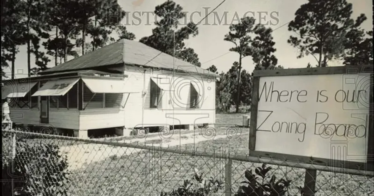
You might wonder: why all this bureaucracy? Can’t I just build what I want on my own property?
The answer lies in a fundamental principle: what you do with your property affects others.
Zoning emerged in the early 20th century as cities grappled with rapid industrialization. Before zoning laws, factories could be built next to homes, creating health hazards and destroying property values. Slaughterhouses, tanneries, and heavy industry operated without regard for residential neighborhoods.
The 1916 New York City Zoning Resolution, America’s first comprehensive zoning law, was created partly because the massive Equitable Building blocked sunlight from nearby streets, demonstrating how one property owner’s decisions can impact an entire neighborhood.
Today, zoning permits serve several critical functions:
1. Protecting Property Values By ensuring compatible uses are grouped together, zoning helps maintain neighborhood character and property values. Residential zones stay residential, commercial corridors remain vibrant, and industrial areas are separated from homes.
2. Ensuring Infrastructure Adequacy Cities use zoning to manage density and ensure that roads, water systems, sewer capacity, and public services can handle development. An unexpected surge in density can overwhelm infrastructure that took decades to build.
3. Preserving Community Character Historic neighborhoods, downtown districts, and special areas maintain their unique identity through zoning controls on height, design, and use.
4. Environmental Protection Zoning can protect sensitive environmental areas, manage stormwater, preserve open space, and reduce environmental impacts.
5. Public Health and Safety Separation of incompatible uses (factories from schools, bars from churches) and standards for access, parking, and emergency services all promote public welfare.
6. Orderly Growth Rather than chaotic, ad-hoc development, zoning helps cities grow in planned, sustainable ways aligned with community visions.
Importantly, zoning permits also protect your rights as a property owner. The permit process:
Here’s where theory meets reality — and where most people hit a wall.
Understanding whether your project needs a zoning permit, what type you need, and what requirements apply sounds straightforward. In practice, it’s anything but.
Consider what you need to determine before submitting a permit application:
For a residential addition:
For a new business:
1. Complex, Technical Documents Municipal zoning codes often span hundreds of pages of legal text. The City of Berkeley’s zoning ordinance, for example, is divided into multiple chapters with cross-references, exceptions, and technical definitions that require expertise to interpret correctly.
2. Multiple Information Sources Finding answers requires accessing:
These often exist across different websites, PDF documents, and physical planning counters.
3. Location-Specific Requirements Zoning isn’t one-size-fits-all. Requirements vary based on:
4. Spatial Understanding Required Many zoning questions are inherently spatial:
Without GIS expertise, answering these questions means hours of map scrolling and manual cross-referencing.
5. Interpretation Nuances Even seemingly clear regulations require interpretation:
Inadequate research leads to:
Sarah wants to build an ADU (Accessory Dwelling Unit) in her backyard for rental income. She needs to know:
Without clear answers, she risks spending $5,000+ on architectural plans only to discover the ADU isn’t allowed or must be significantly modified.
Marcus owns a retail shop and wants to add a coffee bar. This seemingly simple change triggers zoning questions:
Getting these answers from city staff might mean multiple phone calls, visits, and weeks of waiting — during which his renovation timeline stalls.
A development firm is considering purchasing a vacant lot for a mixed-use project. Before committing millions, they need comprehensive due diligence:
This research traditionally requires hiring planning consultants at $150–300/hour, GIS analysts, and extensive staff time — before even submitting an application.
Historically, getting zoning information meant:
1. Visiting City Hall Schedule time during business hours, wait in line, speak with a planner who may need to research your question, and hope you’ve asked all the right questions.
2. Navigating Complex Websites Dig through municipal websites with varying organization, download large PDF documents, and attempt to interpret technical language without training.
3. Calling Planning Departments Leave messages, wait for callbacks, explain your project repeatedly to different staff members, and receive information limited by what one person knows or has time to explain.
4. Hiring Consultants Pay thousands of dollars to architects, land use attorneys, or planning consultants who have the expertise to navigate the system.
5. Using GIS Mapping Software For spatial questions, you need access to (and training in) professional GIS software like ArcGIS — tools designed for specialists, not the general public.
All these approaches share a common flaw: they create barriers between people and the information they need.
Even city staff face these challenges. Planners spend 75% of their time answering routine questions instead of focusing on high-value planning work. They are constantly context-switching between inquiries, researching answers, and creating one-off explanations for common questions.
What if getting zoning information was as simple as asking a question in plain English?
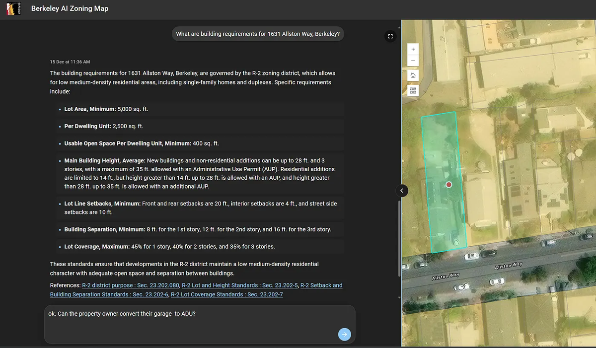
What if you could ask, “Can I build an ADU at 123 Maple Street?” and instantly receive both a clear written answer and a visual map showing exactly where on your property the ADU could be built?
This is not a future vision. It is happening now.
Conflation Labs has created a smart conversational assistant that solves the fundamental information access problem in municipal planning. By combining advanced AI language models with authoritative GIS data and city documents, we’re transforming how people interact with zoning information.
Our platform operates on three core principles:
1. Natural Conversation Ask questions the way you’d ask a city planner:
No need to learn technical terminology or navigate complex websites. Just ask.
2. Spatial Intelligence Built In Unlike traditional chatbots that can only search text documents, Conflation Labs understands location. We integrate with your city’s GIS data to provide visual, map-based answers alongside written explanations.
When you ask about specific parcels, zoning districts, or location-based requirements, you receive:
3. Authoritative and Up to Date Our system connects directly to your city’s official documents and GIS databases, the same sources city planners use. This means:
Standard chatbots are essentially sophisticated search engines. They scan websites and answer basic questions like “What are your office hours?” or “Where do I apply for a business license?”
But they fail when you need:
Conflation Labs goes far beyond simple search. We provide intelligent, location-aware guidance that combines regulatory knowledge with spatial analysis.
Zoning & Property Information:
Policy Navigation:
Business Permitting:
Residential Permitting:
The benefits extend across the entire planning ecosystem:
For Residents:
For Business Owners:
For City Staff:
For Developers:
One of our most powerful features is the ability to generate custom property maps that transform complex zoning requirements into clear visual insights:
These are not generic templates. Each map is customized to your exact parcel using real GIS data.
We believe government information should be accessible to everyone, not just those with technical expertise, expensive consultants, or hours to spend researching.
Zoning codes exist to serve the public good, to create safe, thriving, well-planned communities. But when these regulations are locked behind barriers of complexity and access, they cannot serve their purpose effectively.
By making municipal codes conversational and spatial information visual, we’re democratizing access to planning information. Whether you’re a homeowner with a weekend project, an entrepreneur starting a business, or city staff serving your community, you deserve clear, instant answers to zoning questions.
We are actively working with cities as design partners to build platforms customized to their specific needs. As a design partner, your city will:
This is a partnership investment in the future of municipal services with minimal cost for potentially transformative impact.
Are you tired of spending hours researching zoning questions? Want to understand what’s possible on your property or where you can open your business?
Whether you’re a city looking to modernize planning services or an individual seeking zoning information, we’d love to hear from you.
Email: al@conflationlabs.com
Website: www.ConflationLabs.com
“Conflation Labs has become our go-to co-pilot for zoning and site review. Instead of spending hours each week responding to ‘What can I build here?’ inquiries, staff now receive clear, map-based answers in seconds.”
J.D. Suarez, Senior Planner, City of Riviera Beach, FL
Q: Do I always need a zoning permit AND a building permit?
A: Often yes, but it depends on the project. Some projects get zoning clearance as part of the building permit review (by-right projects). Others require a separate zoning permit first. Think of zoning as the “what and where” approval, and building permits as the “how” approval.
Q: How long does it take to get a zoning permit?
A: It varies widely based on permit type. Zoning Certificates for by-right projects can be approved in days. Administrative Use Permits typically take 4–8 weeks. Use Permits requiring public hearings may take 3–6 months, especially if environmental review is needed.
Q: Can I appeal a zoning permit decision?
A: Yes. Most zoning decisions have appeal processes, typically starting with a zoning board and potentially advancing to city council. Appeal rights and timelines are specified in your local zoning ordinance.
Q: What happens if I build without a required zoning permit?
A: Building without proper permits can result in stop-work orders, fines, required removal of unpermitted work, difficulty selling your property, and problems with insurance claims. Always verify permit requirements before starting work.
Q: How does Conflation Labs stay current with zoning changes?
A: Our platform connects directly to cities’ authoritative data sources and documents. When cities update zoning codes or GIS data, those changes are reflected in our system, ensuring answers are always based on current regulations.
Q: Is this replacing city planners?
A: Absolutely not. We’re empowering planners by handling routine questions, allowing them to focus on complex projects, strategic planning, and high-value work that requires human judgment and expertise. Think of it as a tool that amplifies what planners can accomplish.
← Back to all blog posts
Originally published here