
Berkeley, CA Zoning Map, Districts & Ordinance
All 28 zoning districts on Berkeley's official zoning map, with the sections that govern each one and the rules they share. Type an address to see its district and ask what you can build.
Your first answer is free. No account needed.
28
zoning districts on the city's map
40
governing code sections mapped
326
district-to-section links in the knowledge graph
76%
of districted land is residential
42
polygons on the city's zoning map
121,749
residents (Census)
Zoning map
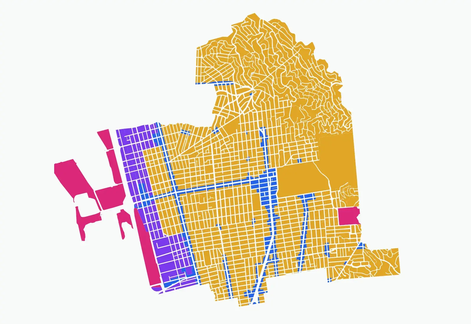
Berkeley zoning map
Residential Multi-Unit 1 (R-1) is the largest district at 1,605 ac. Residential districts cover 76% of districted land. The map is drawn from the city's “Zoning Districts” layer, 42 polygons, last edited by the city on Jun 6, 2025.
Ordinance knowledge graph
How Berkeley's districts connect to the code
Each district has its own sections in the code, and it also pulls in rules that live elsewhere. This grid shows which shared rules apply to which district. A filled cell is a cross-reference we read from the ordinance.
District
Supplemental use-specific regulations§23.302.070 · 26/28
Lot requirements§23.304.020 · 25/28
Setbacks§23.304.030 · 25/28
Usable open space§23.304.090 · 23/28
Building height§23.304.050 · 22/28
Accessory Dwelling Units (Chapter 23.306)§23.306 · 22/28
Lot coverage§23.304.120 · 20/28
Building separation in residential districts§23.304.040 · 17/28
Parking and loading (Chapter 23.322)§23.322 · 11/28
Residential Density (measurement)§23.106.100 · 8/28
Non-residential districts abutting a residential district§23.304.130 · 8/28
Hillside Overlay Zone§23.210.020 · 3/28
Floor Area Ratio (measurement)§23.106.050 · 1/28
ES-REnvironmental Safety-Residential
R-3Multiple-Family Residential
R-BMUResidential BART Mixed Use
R-SMUResidential Southside Mixed Use
C-ACAdeline Corridor Commercial
C-DMUDowntown Mixed-Use
C-TTelegraph Avenue Commercial
C-UUniversity Avenue Commercial
M-RDManufacturing, Research and Development
Berkeley zoning districts
| District | Family | What it is for | Area | Governing sections |
|---|---|---|---|---|
| ES-R Environmental Safety-Residential | Residential | Panoramic Hill district limiting development because of steep slopes, poor access, fire and earthquake hazards; no new dwelling units until a Panoramic Hill Specific Plan is adopted, 25,000 sq. ft. minimum lots and 0.3 FAR. | 24 ac | §23.202.020, §23.202.030, §23.202.040, §23.202.070 |
| R-1 Residential Multi-Unit 1 | Residential | Residential district for housing types from single-family homes to small apartment buildings, allowing 35 ft. and 3 stories and 10 to 70 dwelling units per acre, with stricter standards where the Hillside Overlay applies (R-1H). | 1,605 ac | §23.202.020, §23.202.030, §23.202.040, §23.202.050 |
| R-2 Residential Multi-Unit 2 | Residential | Residential district encouraging a range of housing types at 35 ft. and 3 stories and 10 to 70 dwelling units per acre, with story-based setbacks and coverage limits where the Hillside Overlay applies (R-2H). | 964 ac | §23.202.020, §23.202.030, §23.202.040, §23.202.080 |
| R-2A Residential Multi-Unit 2A | Residential | Residential district for apartment-type housing with open space at 35 ft. and 3 stories and 20 to 70 dwelling units per acre; the Hillside Overlay (R-2AH) adds 1,650 sq. ft. of lot area per unit and story-based setbacks. | 452 ac | §23.202.020, §23.202.030, §23.202.040, §23.202.090 |
| R-3 Multiple-Family Residential | Residential | Relatively high-density residential district with separate standards inside the Southside Plan area (45 ft., FAR 3.0, 60 du/acre minimum, 100% coverage) and outside it (35 ft. and 3 stories, story-based setbacks). | 173 ac | §23.202.020, §23.202.030, §23.202.040, §23.202.100 |
| R-4 Multi-Family Residential | Residential | Relatively high-density multi-family district allowing residential hotels and some office uses, 35 ft. and 3 stories by right and up to 65 ft. and 6 stories with a Use Permit, with setbacks and coverage stepping by story. | 50 ac | §23.202.020, §23.202.030, §23.202.040, §23.202.110 |
| R-5 High-Density Residential | Residential | High-density, multi-story residential district near shopping, transit and jobs, allowing 40 ft. and 4 stories by right and up to 65 ft. and 6 stories with a Use Permit, with small open-space requirements. | 404 ac | §23.202.020, §23.202.030, §23.202.040, §23.202.120 |
| R-BMU Residential BART Mixed Use | Residential | Mixed-use district for the Ashby and North Berkeley BART station sites (AB 2923) with a Master Development Permit process, FAR 4.2, 80 ft. and 7 stories, 75 du/acre minimum and required public open space. | 16 ac | §23.202.020, §23.202.030, §23.202.040, §23.202.150 |
| R-S Residential Southside | Residential | Southside Plan residential district for high and moderate-density multi-story housing near campus and transit, with a 100 du/acre minimum, FAR 4.0, 55 ft. maximum height and 100% lot coverage. | 15 ac | §23.202.020, §23.202.030, §23.202.040, §23.202.130 |
| R-SMU Residential Southside Mixed Use | Residential | Southside Plan high-density mixed-use residential district with neighborhood-serving retail and offices, a 150 du/acre minimum, FAR 7.0, 85 ft. maximum height and 100% lot coverage. | 50 ac | §23.202.020, §23.202.030, §23.202.040, §23.202.140 |
| C-AC Adeline Corridor Commercial | Commercial | Adeline Corridor Specific Plan district where FAR, height and density rise in tiers with on-site affordable housing (up to 300 du/acre and 90 ft. in South Shattuck), with active ground-floor commercial on key frontages. | 41 ac | §23.204.020, §23.204.030, §23.204.040, §23.204.150 |
| C-C Corridor Commercial | Commercial | Avenue Commercial district for a wide variety of activities along thoroughfares, FAR 3.0 for non-residential and mixed use, 40 ft. heights (50 ft. and 4 stories for mixed use with a Use Permit) and 100% coverage. | 24 ac | §23.204.020, §23.204.030, §23.204.040, §23.204.050 |
| C-DMU Downtown Mixed-Use | Commercial | Downtown Area Plan district with Core, Outer Core, Corridor and Buffer sub-areas, heights of 50 to 60 ft. (75 ft. with a Use Permit), up to five taller buildings to 180 ft., and LEED Gold for new buildings. | 65 ac | §23.204.020, §23.204.030, §23.204.040, §23.204.130 |
| C-E Elmwood Commercial | Commercial | Elmwood community commercial district keeping a neighborhood scale of retail and services, with FAR 0.8 to 1.0, 28 ft. and 2 stories for commercial and mixed use, and size caps on certain shops. | 5 ac | §23.204.020, §23.204.030, §23.204.040, §23.204.080 |
| C-N Neighborhood Commercial | Commercial | Neighborhood Commercial district for convenience goods and services for nearby residents, FAR 3.0 for non-residential and mixed use, 35 ft. heights and controls protecting adjacent residential areas. | 16 ac | §23.204.020, §23.204.030, §23.204.040, §23.204.070 |
| C-NS North Shattuck Commercial | Commercial | North Shattuck neighborhood-serving commercial district limiting high-traffic and office uses, with FAR 1.0 for non-residential projects, 35 ft. and 3 stories for commercial and mixed use and a 2-story minimum. | 13 ac | §23.204.020, §23.204.030, §23.204.040, §23.204.090 |
| C-SA South Area Commercial | Commercial | South Berkeley community and regional commercial district under the South Berkeley Area Plan, FAR 4.0 for non-residential and mixed use, 60 ft. and 5 stories for mixed use in Subarea One and indoor-only vehicle sales. | 32 ac | §23.204.020, §23.204.030, §23.204.040, §23.204.100 |
| C-SO Solano Avenue Commercial | Commercial | Solano Avenue neighborhood commercial district serving local everyday needs, with FAR 2.0 for non-residential and mixed use, a 28 ft. and 2-story height limit and limits on commercial impacts next to residential districts. | 8 ac | §23.204.020, §23.204.030, §23.204.040, §23.204.120 |
| C-T Telegraph Avenue Commercial | Commercial | Telegraph Avenue district serving the University and Southside population, with a 200 du/acre minimum, FAR 8.0, heights of 35 to 85 ft., 100% coverage and no off-street parking requirement. | 16 ac | §23.204.020, §23.204.030, §23.204.040, §23.204.110 |
| C-U University Avenue Commercial | Commercial | University Avenue corridor district implementing the University Avenue Strategic Plan, with node and avenue sub-areas, FAR 2.2 to 3.0, heights of 36 to 48 ft. and required ground-floor commercial space. | 28 ac | §23.204.020, §23.204.030, §23.204.040, §23.204.060 |
| C-W West Berkeley Commercial | Commercial | West Berkeley Plan commercial district along San Pablo Avenue with designated pedestrian nodes, FAR 3.0, 40 ft. and 3 stories (50 ft. and 4 stories for mixed use) and size-based permits for mixed-use residential. | 109 ac | §23.204.020, §23.204.030, §23.204.040, §23.204.140 |
| M Manufacturing | Industrial | West Berkeley general manufacturing district for the full range of manufacturers including heavy materials processing, plus vehicle sales, with a 20,000 sq. ft. minimum lot, FAR 2.0, 45 ft. height and no setbacks. | 50 ac | §23.206.020, §23.206.030, §23.206.040, §23.206.060, §23.206.110 |
| M-RD Manufacturing, Research and Development | Industrial | District for light manufacturing and research and development with supporting office and lab uses, FAR 2.0, 80% coverage and 55 ft. height, rising to 105 ft. on campus-style sites of at least 9 acres. | 11 ac | §23.206.020, §23.206.030, §23.206.040, §23.206.100, §23.206.110 |
| MM Mixed Manufacturing | Industrial | West Berkeley mixed manufacturing district for heavy and light manufacturing plus research and development, with upper-floor offices, protected industrial space, a 20,000 sq. ft. minimum lot, FAR 2.0 and 45 ft. height. | 62 ac | §23.206.020, §23.206.030, §23.206.040, §23.206.050, §23.206.070, §23.206.110 |
| MU-LI Mixed Use-Light Industrial | Industrial | West Berkeley light industrial district for light manufacturing, labs, R&D and limited office and retail, protecting industrial building stock, with no minimum lot, FAR 2.0, 45 ft. height and no setbacks. | 190 ac | §23.206.020, §23.206.030, §23.206.040, §23.206.050, §23.206.080, §23.206.110 |
| MU-R Mixed Use-Residential | Industrial | West Berkeley transition district mixing residential, live/work, light industrial and arts uses, with 20 to 70 dwelling units per acre, non-residential FAR 1.5 and heights of 28 to 35 ft. | 72 ac | §23.206.020, §23.206.030, §23.206.040, §23.206.050, §23.206.090, §23.206.110 |
| SP Specific Plan | Special purpose | District for areas under an adopted Specific Plan, where allowed uses and permit requirements come from that plan and a Master Development Plan Permit is required before other permits. | 152 ac | §23.208.010 |
| U Unclassified | Special purpose | Holding district for areas not yet classified as residential, commercial or manufacturing; any lawful use needs a Use Permit and all development standards are set in that permit. | 297 ac | §23.108.020, §23.208.020 |
Start from what you want to build in Berkeley
Answered from Berkeley's ordinance. Each one opens the app with the question filled in.
How many units per acre can I build in R-1?
R-1 allows 10 to 70 dwelling units per acre, in buildings up to 35 feet and 3 stories.
§23.202.050
Ask this →
Can I build multi-unit housing on a hillside lot in R-2?
Not where the Hillside Overlay applies: multi-unit housing is not permitted in R-2H.
§23.210.020
Ask this →
How tall can buildings be in downtown Berkeley?
C-DMU allows 50 to 60 feet, or 75 feet with a Use Permit, plus up to five taller buildings, the tallest up to 180 feet.
§23.204.130
Ask this →
What can I build in the U district?
U is a holding district: any lawful use needs a Use Permit, and that permit sets all development standards.
§23.208.020
Ask this →
Where this page's data comes from
Zoning code: Berkeley Municipal Code, Title 23 (Zoning).
Zoning map: City of Berkeley, “Zoning Districts” layer, verified in our national corpus. Last edited by the city on Jun 6, 2025.
District areas: summed from the polygons on that layer.
Berkeley zoning questions
How many zoning districts does Berkeley have?
Berkeley Municipal Code, Title 23 (Zoning) defines 28 zoning districts.
Which rules apply in every Berkeley district?
No shared rule is referenced by every district. Supplemental use-specific regulations (§23.302.070) reaches the most, 26 of 28.
Where is the Berkeley zoning code published?
Berkeley Municipal Code, Title 23 (Zoning). Every answer we give links the exact section.
Zoning near Berkeley
California: 369 of 482 places have a published zoning map in our corpus.
Check any Berkeley address
District, standards and the code section behind each answer. Pay as you go after your first answer.
Zoning information is for research, not legal advice. Confirm with the Berkeley planning division before you buy or design.