
Vallejo, CA Zoning Map, Districts & Ordinance
All 18 zoning districts in Vallejo's code, mapped from the city's official zoning layer, with the sections that govern each one and the rules they share. Type an address to see its district and ask what you can build.
Your first answer is free. No account needed.
18
base zoning districts in the code
22
governing code sections mapped
173
district-to-section links in the knowledge graph
36%
of districted land is residential
39,183
parcels on the city's zoning map
123,475
residents (Census)
Zoning map
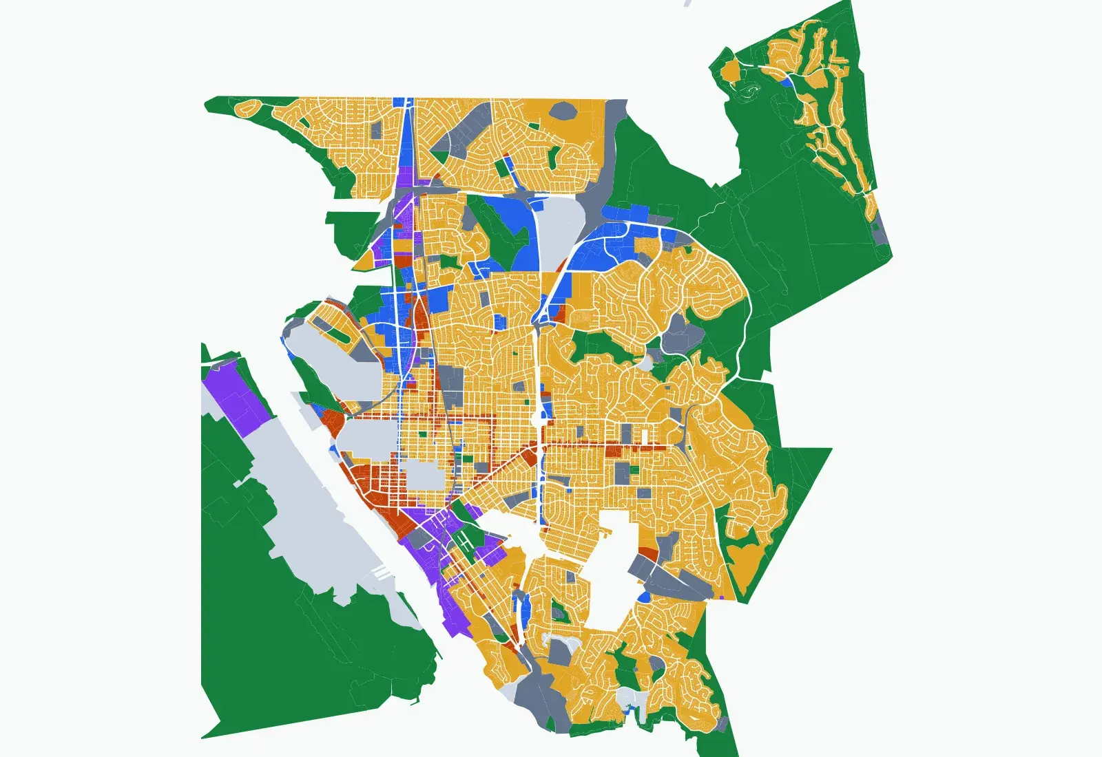
Vallejo zoning map
Resource Conservation (RCN) is the largest district at 6,009 ac. Residential districts cover 36% of districted land. The map is drawn from the city's “Zoning Code” layer, 39,183 parcels, last edited by the city on Aug 17, 2026.
Ordinance knowledge graph
How Vallejo's districts connect to the code
Each district has its own sections in the code, and it also pulls in rules that live elsewhere. This grid shows which shared rules apply to which district. A filled cell is a cross-reference we read from the ordinance.
District
Height Exceptions§16.501.05 · 18/18
Landscaping§16.504 · 18/18
Projections into Required Yards§16.501.07 · 16/18
Fences, Walls, and Screening§16.505 · 15/18
Lighting§16.506 · 15/18
Off-Street Parking and Loading§16.508 · 15/18
Measuring Building Height§16.104.13 · 11/18
Mixed-Use Development Standards§16.214 · 6/18
Hillside Development Standards§16.212 · 4/18
Accessory Buildings and Structures§16.501.02 · 4/18
Vallejo zoning districts
| District | Family | What it is for | Area | Governing sections |
|---|---|---|---|---|
| RHD Residential High Density | Residential | High-density residential district allowing a mix of housing types with a maximum density of 40 units per acre (50 for Business/Limited Residential GP designation) and mixed-use development. | 68 ac | §16.202.01, §16.202.04 |
| RLD Residential Low Density | Residential | Low-density residential district for permanent single-unit residences including detached and attached units, duplexes, townhouses, and small neighborhood-serving retail, with a maximum density of 9 units per acre. | 5,814 ac | §16.202.01, §16.202.02, §16.202.03, §16.202.05 |
| RMD Residential Medium Density | Residential | Medium-density residential district accommodating a mix of housing types including attached, detached, and small apartment buildings with a maximum density of 25 units per acre. | 977 ac | §16.202.01, §16.202.04, §16.202.05 |
| RR Rural Residential | Residential | Very low-density residential district intended for rural residential, agriculture, open space, and supporting public service facilities with a minimum lot size of 2.5 acres. | 146 ac | §16.202.01, §16.202.02 |
| DMX Downtown Mixed Use | Mixed use | Downtown mixed-use district promoting a vibrant, pedestrian-oriented environment integrating downtown with the waterfront, allowing up to 8 stories with minimal setbacks and active ground-floor uses. | 71 ac | §16.203.01, §16.203.02, §16.203.03 |
| NMX Neighborhood Mixed Use | Mixed use | Neighborhood-serving mixed-use district along primary commercial corridors with design standards ensuring development is appropriately scaled relative to adjacent single-family neighborhoods, up to 5 stories. | 319 ac | §16.203.01, §16.203.02, §16.203.03 |
| WMX Waterfront Mixed Use | Mixed use | Waterfront mixed-use district allowing waterfront shopping, services, activities, and residential development, implementing the Waterfront Planned Development Master Plan with required public shoreline access. | 103 ac | §16.203.01, §16.203.02, §16.203.03 |
| CC Central Corridor Commercial | Commercial | Community-serving mixed-use district along Sonoma Boulevard Central Corridor accommodating housing, medium/high density residential, and non-residential uses at street level, up to 8 stories. | 209 ac | §16.204.01, §16.204.02, §16.204.03 |
| M Medical | Commercial | Medical district intended for concentrations of medical facilities and supporting commercial services with buffering and transitions to adjacent residential neighborhoods. | 62 ac | §16.205.01, §16.205.02 |
| NC Neighborhood Commercial | Commercial | Small-site neighborhood commercial district providing limited retail goods and services to meet day-to-day needs of local residents, up to 3 stories. | 9 ac | §16.204.01, §16.204.02, §16.204.03 |
| O Office | Commercial | Employment-focused office district supporting a mix of uses including business-supportive services, with residential-only and office-with-residential development allowed subject to compatibility standards. | 21 ac | §16.205.01, §16.205.02 |
| RC Regional Commercial | Commercial | Regional-scale commercial district providing general retail, services, commercial recreation and entertainment for local residents and regional visitors, accommodating auto-oriented uses with residential buffering. | 457 ac | §16.204.01, §16.204.02, §16.204.03 |
| WC Waterfront Commercial | Commercial | Waterfront commercial district providing waterfront-related retail, service uses, and visitor accommodations in building forms scaled to the waterfront, with no residential uses and required public shoreline access. | 18 ac | §16.204.01, §16.204.02, §16.204.03 |
| IG General Industrial | Industrial | General industrial district for a broad range of industrial activities including heavy industrial, manufacturing, and supportive offices, with buffering standards for adjacent residential uses. | 254 ac | §16.206.01, §16.206.02, §16.206.03 |
| IL Light Industrial | Industrial | Light industrial district accommodating a diverse range of light industrial, supportive uses, limited office, and live/work uses, primarily for industrial and flex space development. | 251 ac | §16.206.01, §16.206.02, §16.206.03 |
| PROS Parks, Recreation and Open Space | Open space | Parks, recreation, and open space district intended for parks, recreational facilities, and natural resource preservation with a 50-foot setback buffer on all sides. | 3,530 ac | §16.207.01, §16.207.02, §16.207.03 |
| RCN Resource Conservation | Open space | Resource conservation district preserving remaining open spaces in their natural state, protecting wetlands, mudflats, creek corridors, wildlife habitat, and deed-restricted open space lands. | 6,009 ac | §16.207.01, §16.207.02, §16.207.03 |
| PS Public and Semi-Public | Public / civic | Public and semi-public district regulating areas that provide governmental and quasi-governmental services, community facilities, and supportive services with compatibility standards for adjacent residential areas. | 1,351 ac | §16.208.01, §16.208.02, §16.208.03 |
The map also shows specific plan areas and parcels with no zone (mare island, solano360, hiddenbrooke and others) (1,526 ac) and planned development (83 ac), which follow their own plans.
Start from what you want to build in Vallejo
Answered from Vallejo's ordinance. Each one opens the app with the question filled in.
How many units per acre can I build in RHD?
Residential High Density allows up to 40 units per acre.
§16.202.04
Ask this →
Do hillside rules apply to my lot?
Hillside standards are referenced from all four residential districts: RR, RLD, RMD and RHD.
§16.212
Ask this →
What parking does a downtown project need?
Off-street parking and loading rules apply in 15 of 18 districts, DMX included.
§16.508
Ask this →
Can I add an accessory building in RLD?
Accessory building rules are referenced from the four residential districts.
§16.501.02
Ask this →
Where this page's data comes from
Zoning code: Vallejo Municipal Code, Title 16 (Zoning), published on Municode.
Zoning map: City of Vallejo Planning, “Zoning Code” layer, verified in our national corpus. Last edited by the city on Aug 17, 2026.
District areas: summed from the parcels on that layer.
Vallejo zoning questions
How many zoning districts does Vallejo have?
Vallejo Municipal Code, Title 16 (Zoning) defines 18 base zoning districts. The city's map also has planned development and specific plan areas, which follow their own plans.
Which rules apply in every Vallejo district?
Height Exceptions (§16.501.05) and Landscaping (§16.504) are referenced by all 18 districts.
Where is the Vallejo zoning code published?
Vallejo Municipal Code, Title 16 (Zoning), hosted on Municode. Every answer we give links the exact section.
Zoning near Vallejo
California: 369 of 482 places have a published zoning map in our corpus.
Check any Vallejo address
District, standards and the code section behind each answer. Pay as you go after your first answer.
Zoning information is for research, not legal advice. Confirm with the Vallejo planning division before you buy or design.