
Asheville, NC Zoning Map, Districts & Ordinance
41 zoning districts on Asheville's official zoning map, with the sections that govern each one and the rules they share. Type an address to see its district and ask what you can build.
Your first answer is free. No account needed.
41
zoning districts on the city's map
31
governing code sections mapped
325
district-to-section links in the knowledge graph
65%
of districted land is residential
739
polygons on the city's zoning map
94,992
residents (Census)
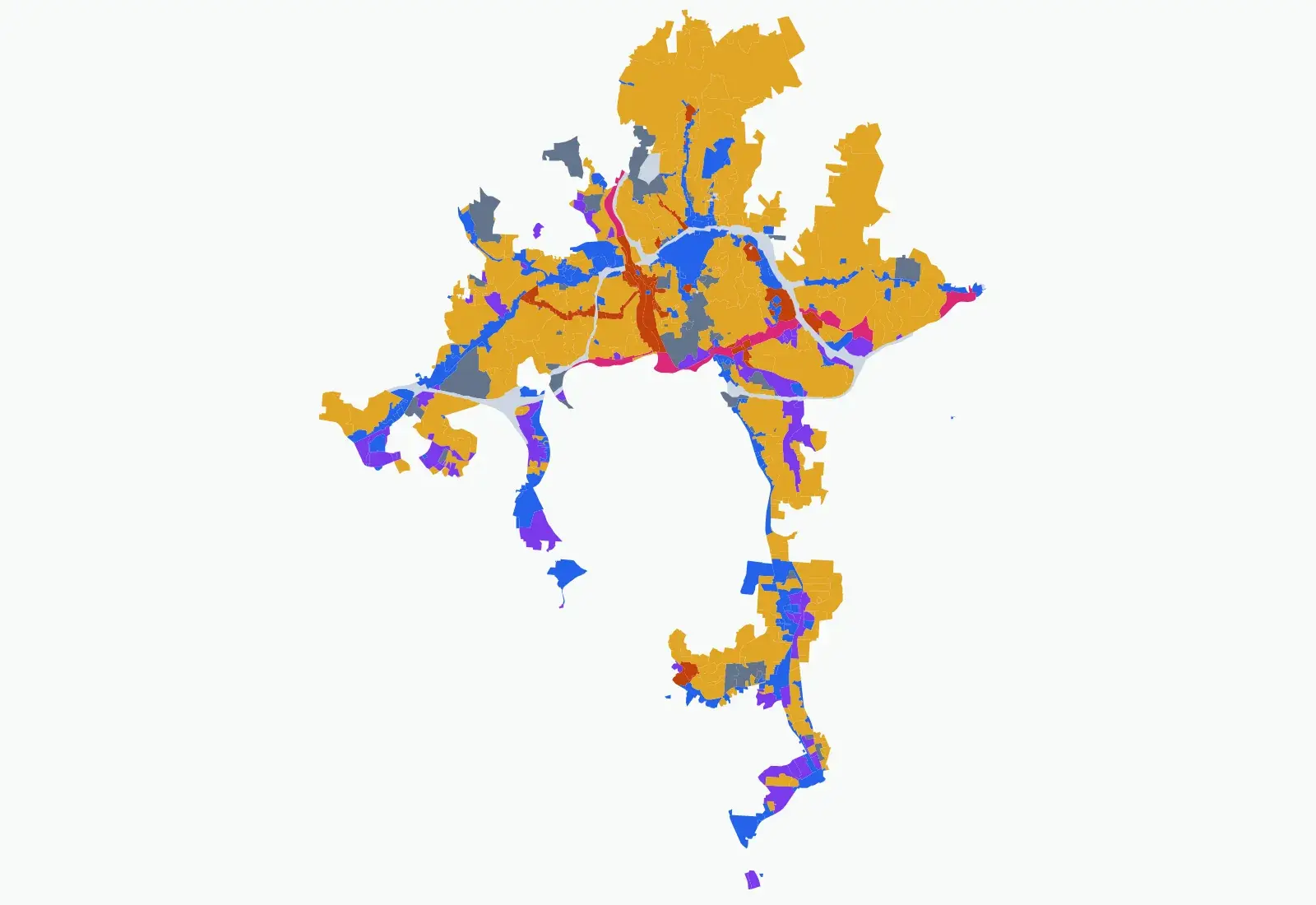
Zoning map
Asheville zoning map
Residential Single-Family Medium Density District (RS4) is the largest district at 5,827 ac. Residential districts cover 65% of districted land. The map is drawn from the city's “Zoning Districts” layer, 739 polygons, last edited by the city on Oct 21, 2026.
Ordinance knowledge graph
How Asheville's districts connect to the code
Each district has its own sections in the code, and it also pulls in rules that live elsewhere. This grid shows which shared rules apply to which district. A filled cell is a cross-reference we read from the ordinance.
District
Table of permitted uses (use-by-district matrix)§7-8-1(d) · 41/41
Parking, loading, and access standards§7-11-2 · 41/41
Landscape and buffering standards§7-11-3 · 41/41
Open space standards§7-11-4 · 40/41
Sidewalk requirements§7-11-8 · 31/41
General development and performance standardsArticle X (Sec. 7-10-1 through 7-10-8) · 19/41
Definitions, including land-use definitions§7-2-5 · 15/41
Traffic impact analysis§7-11-6 · 14/41
Outdoor lighting standards§7-11-10 · 8/41
River Arts Form District: general provisions§7-8-29 §§1.0–2.2 · 7/41
River Arts Form District: uses, parking, signs§7-8-29 §§3.0–6.0 · 7/41
Overlay districtsArticle IX (Sec. 7-9-1 through 7-9-11) · 6/41
Haywood Road Form District: general provisions§7-8-28 §§1.0–2.2 · 6/41
Haywood Road Form District: uses, parking, signs§7-8-28 §§3.0–6.0 · 6/41
Central Business District development standards§7-8-18 · 1/41
RES EXPResidential Expansion
RM16Residential Multi-Family High Density District
RM6Residential Multi-Family Low Density District
RM8Residential Multi-Family Medium Density District
RS2Residential Single-Family Low Density District
RS4Residential Single-Family Medium Density District
RS8Residential Single-Family High Density District
HR-1:COREHR-1: Core
HR-2:EXPNHR-2: Expansion
HR-3:CRDRHR-3: Corridor
HR-4:TRADHR-4: Traditional
HR-6:TOWNHR-6: Town
HR-7:TCHR-7: Traditional Community
NCDNeighborhood Corridor District
RAD-INDIndustrial
RAD-LYHLyman Hollow
RAD-NTNeighborhood Transition
RAD-OSPOpen Space/Public Facilities
RAD-RESResidential
RAD-RIVRiver
RAD-SHPShopfront
CBD EXPCentral Business Expansion District
CBICommunity Business I District
CBIICommunity Business II District
COM EXPCommercial Expansion District
NBNeighborhood Business District
OFFICEOffice District
RESORTResort District
CICommercial Industrial District
RIVERRiver District
Asheville zoning districts
| District | Family | What it is for | Area | Governing sections |
|---|---|---|---|---|
| RES EXP Residential Expansion | Residential | A conditional residential district, applied for through rezoning, permitting a full range of high-density single- and multi-family housing for Level III developments located near employment centers, shopping, roads, and urban infrastructure. | 294 ac | §7-8-42 |
| RM16 Residential Multi-Family High Density District | Residential | A high-density multi-family residential district permitting a full range of high-density housing types plus limited institutional, public, and commercial uses, intended near employment centers, shopping, and urban infrastructure. | 1,146 ac | §7-8-7 |
| RM6 Residential Multi-Family Low Density District | Residential | A low-density residential district permitting a limited range of low-density multi-family housing types alongside single-family detached and attached dwellings, intended as a transitional area between lower- and higher-density areas with compatible supporting non-residential uses. | 2,026 ac | §7-8-5 |
| RM8 Residential Multi-Family Medium Density District | Residential | A medium-density residential district permitting a full range of medium-density multi-family housing types along with single-family detached and attached residences, serving as a transitional area between high-density single-family and multi-family areas. | 2,330 ac | §7-8-6 |
| RS2 Residential Single-Family Low Density District | Residential | A low-density single-family residential district establishing large minimum lot sizes for detached dwellings and compatible uses, intended to recognize environmental constraints such as steep slopes, flooding, and watersheds while protecting residential character. | 2,539 ac | §7-8-2 |
| RS4 Residential Single-Family Medium Density District | Residential | A medium-density single-family residential district intended to stabilize and protect residential character while permitting non-single-family development needed for a balanced, attractive residential area; density set by minimum lot size. | 5,827 ac | §7-8-3 |
| RS8 Residential Single-Family High Density District | Residential | A high-density single-family residential district intended to establish high density per acre for single-family dwellings where public infrastructure is sufficient, stabilizing the residential character of existing high-density single-family areas. | 3,665 ac | §7-8-4 |
| URD Urban Residential District | Residential | A residential district complementing existing neighborhoods with diverse, urban-scaled housing types on transit corridors and high-growth areas, emphasizing pedestrian orientation, connectivity, and a mix of compatible supporting uses. | 8 ac | §7-8-25 |
| HR-1:CORE HR-1: Core | Mixed use | HR-1: Core is the Haywood Road Form District sub-district preserving the historic character of the corridor's two traditional centers, pulling mixed-use buildings to the sidewalk with ground-floor commercial and upper-floor residential and office uses. | 27 ac | §7-8-28 |
| HR-2:EXPN HR-2: Expansion | Mixed use | HR-2: Expansion is a Haywood Road Form District sub-area extending the urban character of the Core, allowing taller new mixed-use and residential buildings pulled up to the sidewalk to encourage pedestrian activity. | 45 ac | §7-8-28 |
| HR-3:CRDR HR-3: Corridor | Mixed use | HR-3: Corridor is a Haywood Road Form District sub-district providing a green frontage along Haywood Road, allowing a variety of uses with a focus on residential and office, with active ground-floor buildings pulled to the sidewalk and residential buildings set slightly back. | 50 ac | §7-8-28 |
| HR-4:TRAD HR-4: Traditional | Mixed use | A Haywood Road form-based sub-district preserving the corridor's traditional center character with mixed-use, sidewalk-fronting buildings up to two stories/35 feet, commercial ground floors, and residential/office upper floors or fully residential buildings. | 8 ac | §7-8-28 |
| HR-6:TOWN HR-6: Town | Mixed use | HR-6: Town is a Haywood Road Form District sub-district creating a new center of activity at Haywood Road and Patton Avenue, encouraging taller mixed-use buildings pulled to the sidewalk with ground-floor commercial and upper-floor residential/office uses. | 29 ac | §7-8-28 |
| HR-7:TC HR-7: Traditional Community | Mixed use | A Haywood Road Form District sub-district that, sharing standards with HR-4: Traditional, preserves existing buildings and expands the historic center, pulling mixed-use and residential buildings up to the sidewalk for pedestrian activity. | 9 ac | §7-8-28 |
| NCD Neighborhood Corridor District | Mixed use | A mixed-use district fostering medium-density, pedestrian-oriented, neighborhood-scaled mixed-use development along connector corridors, with structures that relate to the street, enhance the streetscape, and offer services to surrounding neighborhoods. | 32 ac | §7-8-24 |
| RAD-IND Industrial | Mixed use | RAD-IND is the Industrial sub-district of Asheville's River Arts Form District (Sec. 7-8-29), accommodating small and large-scale industrial buildings up to five stories that conform to flood-zone protection requirements, with a broad range of manufacturing uses. | 18 ac | §7-8-29 |
| RAD-LYH Lyman Hollow | Mixed use | RAD-LYH (Lyman Hollow) is a sub-district of Asheville's River Arts Form District accommodating large-scale residential, commercial and mixed-use buildings up to five stories, allowing a broad range of commercial, employment, light industrial and residential activity. | 8 ac | §7-8-29 |
| RAD-NT Neighborhood Transition | Mixed use | A sub-district of Asheville's River Arts Form District that accommodates a variety of small-scale residential, commercial, and mixed-use buildings stepping down in height as they transition toward adjacent residential zoning along the area's topography. | 42 ac | §7-8-29 |
| RAD-OSP Open Space/Public Facilities | Mixed use | River Arts Form District open-space/public-facilities sub-district providing for public parks, recreation, natural areas, trails, and wetlands owned, leased, or managed by local government, with flexible building placement and a 40-foot height limit. | 163 ac | §7-8-29 |
| RAD-RES Residential | Mixed use | RAD-RES (Residential) is a sub-district of Asheville's River Arts Form District (Sec. 7-8-29) accommodating a variety of small-scale residential buildings pulled up to the sidewalk, limited to three stories, with live/work and home occupations allowed. | 4 ac | §7-8-29, §7-8-29 (2.3) |
| RAD-RIV River | Mixed use | River sub-district of Asheville's River Arts Form District, accommodating medium-to-large residential, commercial, manufacturing, industrial and mixed-use buildings up to five stories that conform to flood-zone protection requirements. | 148 ac | §7-8-29 |
| RAD-SHP Shopfront | Mixed use | RAD-SHP (Shopfront) is a River Arts Form District sub-district accommodating mixed-use buildings up to four stories along narrow, walkable ROWs, with shopfront ground floors pulled to the sidewalk and upper-story stepbacks. | 15 ac | §7-8-29 |
| UP Urban Place Form District | Mixed use | A form-based, transit-supportive district implementing Living Asheville's Urban Centers, guiding higher-density, mixed-use, pedestrian-oriented development with build-to zones, story-based height limits, and an affordable-housing height bonus. | 298 ac | §7-8-26 |
| UV Urban Village District | Mixed use | A mixed-use district creating economically vital, pedestrian-oriented, place-making development with retail, office and residential uses, master-plan-driven on a minimum five-acre site with no maximum residential density or structure-size limit. | 95 ac | §7-8-23 |
| CBD Central Business District | Commercial | Downtown Asheville urban-center district reinforcing the area as the region's primary retail, office, hotel, institutional, cultural, and entertainment center, encouraging supportive retail with high-density residential and design-sensitive infill. | 370 ac | §7-8-18 |
| CBD EXP Central Business Expansion District | Commercial | A conditional district applied for through rezoning, the Central Business Expansion District is reserved for Level III developments within the Central Business District boundaries, prioritizing design, placemaking, and multimodal pedestrian circulation. | 11 ac | §7-8-40 |
| CBI Community Business I District | Commercial | A commercial district providing areas for medium-density business and service uses serving several residential neighborhoods, sensitive to pedestrian populations while providing adequate and safe vehicular access, located primarily along streets serving multiple neighborhoods. | 164 ac | §7-8-12 |
| CBII Community Business II District | Commercial | A commercial district providing for medium-to-high-density business and service uses serving several residential neighborhoods, located primarily along minor and major thoroughfares, balancing pedestrian sensitivity with safe vehicular access. | 246 ac | §7-8-13 |
| COM EXP Commercial Expansion District | Commercial | A conditional commercial district applied for by rezoning, established for large-scale commercial or nonresidential Level III developments that concentrate uses, use infrastructure efficiently, and provide multimodal connectivity through sustainable design. | 377 ac | §7-8-41 |
| HB Highway Business District | Commercial | A commercial district for development along major Asheville thoroughfares, permitting a wide range of commercial uses while enhancing corridor function and appearance as gateways that define the first image of the city. | 1,694 ac | §7-8-16 |
| NB Neighborhood Business District | Commercial | A commercial district reserving areas for low-intensity, pedestrian-accessible business activity serving the daily convenience and personal-service needs of surrounding residential neighborhoods while minimizing conflicts with residential uses. | 20 ac | §7-8-8 |
| O2 Office II District | Commercial | A district reserving areas for small to medium scale office uses compatible with adjacent uses, allowing commercial-predominant mixtures and serving as a transition between residential and commercial areas. | 48 ac | §7-8-10 |
| OB Office/Business District | Commercial | A district reserving an area for office uses and related support uses, accommodating medium-scale offices and a limited range of business uses, and may serve as a transition area between commercial and residential areas. | 119 ac | §7-8-11 |
| OFFICE Office District | Commercial | The Office District reserves areas for small-scale office uses adjacent to residential, permitting a mixture of office and residential uses and serving as a transition between residential and commercial areas, with daytime-oriented activity. | 117 ac | §7-8-9 |
| RB Regional Business District | Commercial | A commercial district established to provide areas for large-scale commercial operations, permitting a wide range of commercial uses, with 35-foot front setbacks and an 80-foot maximum building height. | 393 ac | §7-8-17 |
| RESORT Resort District | Commercial | A commercial district providing for the development and expansion of resort-oriented uses and conference/retreat facilities serving primarily tourists and vacationers, with development standards protecting adjacent land uses from adverse impacts. | 292 ac | §7-8-14 |
| CI Commercial Industrial District | Industrial | A mixed commercial and industrial district providing for light manufacturing, wholesale, warehousing, services, retail sales, offices, and residential uses where environmental conditions and urban infrastructure are adequate to support such development. | 1,689 ac | §7-8-20 |
| IND Industrial District | Industrial | Industrial District reserves land for existing and future industrial activities and supporting land uses, with development standards that protect adjacent districts from the negative impacts of industrial uses. | 473 ac | §7-8-22 |
| LI Light Industrial District | Industrial | The Light Industrial District reserves land for existing and future light industrial, office-warehouse, and related activities, with development standards that protect adjacent districts from the impacts of more intense development types. | 11 ac | §7-8-21 |
| INST Institutional District | Public / civic | The Institutional District reserves land for major educational and medical facilities plus complementary supporting uses such as health-related developments, office developments, and public services, with standards minimizing conflict with adjacent land uses. | 2,051 ac | §7-8-15 |
| RIVER River District | Special purpose | A special-purpose district created to celebrate, conserve, promote, and manage areas along the French Broad and Swannanoa Rivers, allowing a mixture of river-oriented uses while protecting river resources, water quality, and riparian corridors. | 627 ac | §7-8-19 |
The map also shows areas outside these districts: Not zoned (rights-of-way and other land outside any district) (1,032 ac); Institutional Expansion, repealed in 2021 (93 ac); Lodging Expansion, repealed in 2021 (11 ac); HCU, not a district in the current ordinance (4 ac); CBII EXP, not a district in the current ordinance (2 ac).
Start from what you want to build in Asheville
Answered from Asheville's ordinance. Each one opens the app with the question filled in.
What is the minimum lot size in RS-8 in Asheville?
RS-8 needs a lot of at least 4,000 square feet and 40 feet wide, with setbacks of 15 feet in front, 6 feet on the sides and 15 feet in the rear.
§7-8-4
Ask this →
How many apartments can I build on an RM-16 lot?
Two units for the first 2,500 square feet of lot, plus one more for each additional 1,000 square feet. Buildings can be up to 40 feet tall, and new multifamily buildings can have a footprint of up to 4,000 square feet and up to 12,000 square feet of floor area.
§7-8-7
Ask this →
How big can a shop be in Asheville's Neighborhood Business district?
A new building's footprint can be up to 3,000 square feet. In a building of more than one story, commercial space is capped at 6,000 square feet in total; homes have no floor area cap.
§7-8-8
Ask this →
Is outdoor storage allowed in downtown Asheville's Central Business District?
No. Outdoor storage and outdoor warehousing are prohibited in the CBD, except for car and cycle sales and leasing.
§7-8-18
Ask this →
Where this page's data comes from
Zoning code: Asheville Code of Ordinances, Chapter 7 (Unified Development Ordinance), published on American Legal.
Zoning map: City of Asheville, “Zoning Districts” layer, verified in our national corpus. Last edited by the city on Oct 21, 2026.
District areas: summed from the polygons on that layer.
Asheville zoning questions
How many zoning districts does Asheville have?
Our ordinance data for Asheville Code of Ordinances, Chapter 7 (Unified Development Ordinance) covers 42 zoning districts. 41 of them are on the city's zoning map; HR-5:LW is not. The map also has areas outside those districts, listed under the district table.
Which rules apply in every Asheville district?
Table of permitted uses (use-by-district matrix) (§7-8-1(d)), Parking, loading, and access standards (§7-11-2) and Landscape and buffering standards (§7-11-3) are referenced by all 41 districts.
Where is the Asheville zoning code published?
Asheville Code of Ordinances, Chapter 7 (Unified Development Ordinance), hosted on American Legal. Every answer we give links the exact section.
Zoning near Asheville
North Carolina: 164 of 549 places have a published zoning map in our corpus.
Check any Asheville address
District, standards and the code section behind each answer. Pay as you go after your first answer.
Zoning information is for research, not legal advice. Confirm with the Asheville planning division before you buy or design.