
Fairfield, CA Zoning Map, Districts & Ordinance
28 zoning districts on Fairfield's official zoning map, with the sections that govern each one and the rules they share. Type an address to see its district and ask what you can build.
Your first answer is free. No account needed.
28
zoning districts on the city's map
62
governing code sections mapped
903
district-to-section links in the knowledge graph
33%
of districted land is residential
637
polygons on the city's zoning map
122,646
residents (Census)
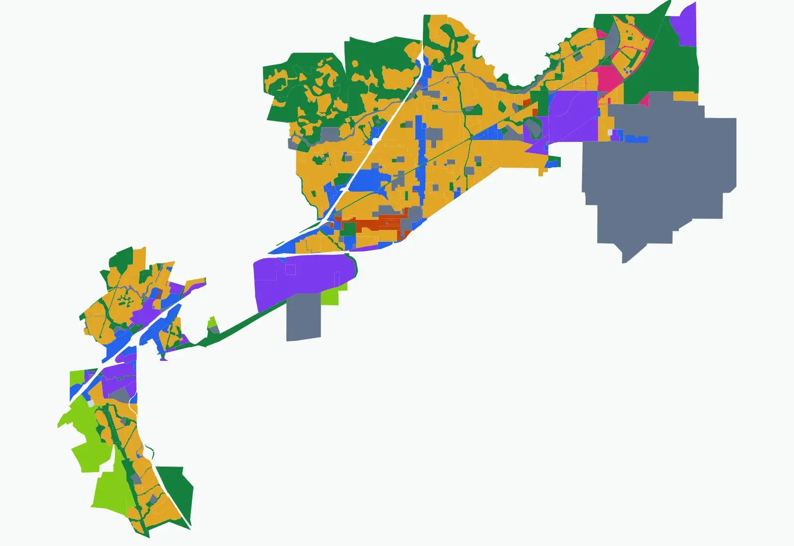
Zoning map
Fairfield zoning map
Public Facilities District (PF) is the largest district at 6,580 ac. Residential districts cover 33% of districted land. The map is drawn from the city's “Zoning” layer, 637 polygons, last edited by the city on Sep 16, 2026.
Ordinance knowledge graph
How Fairfield's districts connect to the code
Each district has its own sections in the code, and it also pulls in rules that live elsewhere. This grid shows which shared rules apply to which district. A filled cell is a cross-reference we read from the ordinance.
District
Parking and loading§25.34 · 28/28
Measurements§25.51 · 28/28
Trash and recyclables enclosures§25.30.7 · 28/28
Grading permit and off-site hauling review§25.240 · 28/28
Grading reports and geotechnical peer review§25.243 · 28/28
Development review for grading and building additionsTable 25-18 · 28/28
Sign prohibitions and express exceptions§25.1309 · 28/28
Existing legal lots and ordinance applicability§25.10.5 · 27/28
Height exceptions, front-yard averaging and projections§25.30.6 · 27/28
Conditional use permits for height and FAR§25.40.6 · 27/28
Bicycle parking ratios and exemption thresholds§25.34.8 · 23/28
Accessory and junior accessory dwelling units§25.20.4.11 · 17/28
Creekside protection / stream environment zoneArticle VIII · 14/28
Condominium conversion affordability and approval§25.32.14 · 14/28
Supportive housing standards§25.32.22 · 13/28
Plan lines and building setback lines§25.30.5 · 13/28
Portable A-frame signs and permitted exceptions§25.1304.C.16 · 12/28
Multifamily open space, recreation amenities, and landscaping§25.20.4.8 · 10/28
Commercial use permissions and ancillary activitiesTable 25-9 · 7/28
Specialty food and beverage market definition§25.50.2 (specialty market) · 7/28
Heart of Fairfield use permissions and notesTable 25-H1 · 7/28
Drive-through stacking and screening§25.22.4.1 · 7/28
Accessory structures and room additions§25.20.4.1 · 6/28
Residential use permissions and notesTable 25-1 · 6/28
Non-residential development in residential districts§25.20.4.9 · 6/28
Outdoor seating, storage, and merchandise display§25.32.9 · 5/28
Mixed-use commercial district exceptions§25.22.4.3 · 5/28
Density bonus§25.38 · 4/28
Small home lot development eligibility and standards§25.20.3.5 · 4/28
Agriculture and public benefit use permissions and notesTable 25-13 · 4/28
Downtown area parking (P1) overlay reduction§25.28.3 · 3/28
RLM without suffix and small-lot single family§25.20.3.2 · 3/28
Alternative multifamily eligibility and Table 25-6§25.20.3.3 · 3/28
Industrial use permissions and notesTable 25-11 · 3/28
RL:10 and RVL ordinary lot dimensions and setbacksTable 25-2 · 2/28
SB 9 urban lot split and two-unit development§25.20.3.4 · 2/28
Farm employee housing approvals and separations§25.32.20 · 2/28
North Cordelia expanded CO uses and standards§25.28.5 · 1/28
Emergency shelter overlay IL-ES§25.28.5B · 1/28
Ordinary IL homeless shelter approval§25.24.4.3 · 1/28
HRHeart of Fairfield Residential District
RHResidential, High Density District
RLResidential, Low Density District
RLMResidential, Low Medium Density District
RMResidential, Medium Density District
RVHResidential, Very High Density District
RVLResidential, Very Low Density District
HDHeart of Fairfield Downtown District
HDCHeart of Fairfield Downtown Core District
HOHeart of Fairfield Mixed Use Office District
HTDHeart of Fairfield Transit-Oriented Development District
HWTHeart of Fairfield West Texas Street District
CCCommunity Commercial District
CNNeighborhood Commercial District
CRRegional Commercial District
CTThoroughfare Commercial District
IBPIndustrial Business Park District
OSCOpen Space/Conservation District
Fairfield zoning districts
| District | Family | What it is for | Area | Governing sections |
|---|---|---|---|---|
| HR Heart of Fairfield Residential District | Residential | Heart of Fairfield residential district covering areas south of the Downtown Core and the Woolner Avenue area, a traditional family-friendly neighborhood of single family homes and smaller apartment buildings with an emphasis on medium densities. | 89 ac | §25.23, §25.23.1, §25.23.2, §25.23.3, §25.23.4, §25.12.2, Table 25-H1, Table 25-H2, Table 25-H3, Table 25-H4, Table 25-H5, §25.10.5, §25.30.6, §25.40.6, §25.34, §25.34.8, §25.32.14 |
| RH Residential, High Density District | Residential | High density district for multifamily development such as apartments and condominiums located along major collector and arterial roads and near employment centers, allowing 19 to 25 dwelling units per gross developable acre. | 578 ac | §25.20, §25.20.1, §25.20.2, §25.20.3, §25.20.4, §25.12.2, §25.20.3.2, §25.20.3.3, Table 25-1, Table 25-4, Table 25-5, Table 25-6, §25.34, §25.10.5, §25.30.5, §25.30.6, §25.40.6, §25.32.22, §25.34.8, §25.32.14 |
| RL Residential, Low Density District | Residential | Low density district for single-family detached homes on minimum lots of 8,000 and 10,000 square feet, with an allowable density range of 2.5 to 4.5 dwelling units per gross developable acre. | 1,874 ac | §25.20, §25.20.1, §25.20.2, §25.20.3, §25.20.4, §25.12.2, Table 25-1, Table 25-2, Table 25-3, §25.20.3.4, §25.10.5, §25.30.5, §25.30.6, §25.40.6, §25.32.22, §25.34, §25.34.8, §25.32.14 |
| RLM Residential, Low Medium Density District | Residential | Low medium density district for single family neighborhoods on minimum lots of 4,500 to 6,000 square feet, allowing 4.5 to 8 dwelling units per gross developable acre and compact small-lot design where no lot-size suffix is applied. | 5,227 ac | §25.20, §25.20.1, §25.20.2, §25.20.3, §25.20.4, §25.12.2, §25.20.3.2, Table 25-1, Table 25-3, Table 25-4, Table 25-5, §25.10.5, §25.30.5, §25.30.6, §25.40.6, §25.32.22, §25.34, §25.34.8, §25.32.14 |
| RM Residential, Medium Density District | Residential | Medium density district for low-density attached housing such as duets, duplexes, triplexes, fourplexes, townhouses and condominiums, with an allowable density range of 10 to 18 dwelling units per gross developable acre. | 786 ac | §25.20, §25.20.1, §25.20.2, §25.20.3, §25.20.4, §25.12.2, §25.20.3.2, §25.20.3.3, Table 25-1, Table 25-4, Table 25-5, Table 25-6, §25.34, §25.10.5, §25.30.5, §25.30.6, §25.40.6, §25.32.22, §25.34.8, §25.32.14 |
| RVH Residential, Very High Density District | Residential | Very high density district for apartments, condominiums and senior housing near transit stations and employment centers, allowing 26 to 40 dwelling units per gross developable acre with typically three- and four-story structures. | 55 ac | §25.20, §25.20.1, §25.20.2, §25.20.3, §25.20.4, §25.12.2, §25.20.3.3, Table 25-1, Table 25-4, Table 25-6, §25.34, §25.10.5, §25.30.5, §25.30.6, §25.40.6, §25.32.22, §25.34.8, §25.32.14 |
| RVL Residential, Very Low Density District | Residential | Very low density district for single-family detached homes on large lots, serving as a transition between urban development and agricultural or open space areas, with a maximum density of 2.5 dwelling units per gross developable acre. | 80 ac | §25.20, §25.20.1, §25.20.2, §25.20.3, §25.20.4, §25.12.2, Table 25-1, Table 25-2, §25.20.3.4, §25.10.5, §25.30.5, §25.30.6, §25.40.6, §25.32.22, §25.34, §25.34.8, §25.32.14 |
| CM Mixed Commercial District | Mixed use | Mixed commercial district applied to transitional areas near the Heart of Fairfield Plan boundary and areas identified by the General Plan as Mixed Use, where permitted uses follow the General Plan description for each mixed use property. | 44 ac | §25.22, §25.22.1, §25.22.2, §25.22.3, §25.22.4, §25.12.2, Table 25-9, Table 25-10, §25.34, §25.10.5, §25.30.6, §25.40.6, §25.50.2 (specialty market), §25.32.22, §25.34.8, §25.32.14 |
| HD Heart of Fairfield Downtown District | Mixed use | Heart of Fairfield downtown district covering parcels between Empire and Missouri Streets east of Pennsylvania Avenue, implementing a mix of specialty shopping, restaurants, entertainment and cultural uses supported by upper-floor residential and office. | 29 ac | §25.23, §25.23.1, §25.23.2, §25.23.3, §25.23.4, §25.12.2, Table 25-H1, Table 25-H2, Table 25-H3, Table 25-H4, §25.10.5, §25.30.6, §25.40.6, §25.34, §25.34.8, §25.28.3, §25.32.14 |
| HDC Heart of Fairfield Downtown Core District | Mixed use | Heart of Fairfield downtown core district applying to properties in the heart of the downtown area along Texas Street and its cross streets, with the most urban form standards in the Plan area. | 13 ac | §25.23, §25.23.1, §25.23.2, §25.23.3, §25.23.4, §25.12.2, Table 25-H1, Table 25-H2, Table 25-H3, Table 25-H4, §25.10.5, §25.30.6, §25.40.6, §25.34, §25.34.8, §25.28.3, §25.32.14 |
| HO Heart of Fairfield Mixed Use Office District | Mixed use | Heart of Fairfield mixed use office district applied to the transition zones north and south of the Downtown and Downtown Core districts, permitting office uses and limited higher density housing while preserving the existing mixed residential-office character. | 50 ac | §25.23, §25.23.1, §25.23.2, §25.23.3, §25.23.4, §25.12.2, Table 25-H1, Table 25-H2, Table 25-H3, Table 25-H4, Table 25-H5, §25.10.5, §25.30.6, §25.40.6, §25.34, §25.34.8, §25.28.3, §25.32.14 |
| HTD Heart of Fairfield Transit-Oriented Development District | Mixed use | Heart of Fairfield transit-oriented development district in the southeastern sector of Downtown near the Suisun-Fairfield Train Station, intended for a new high density residential neighborhood with limited neighborhood-supporting retail and office. | 22 ac | §25.23, §25.23.1, §25.23.2, §25.23.3, §25.23.4, §25.12.2, Table 25-H1, Table 25-H2, Table 25-H3, Table 25-H4, §25.10.5, §25.30.6, §25.40.6, §25.34, §25.34.8, §25.32.14 |
| HWT Heart of Fairfield West Texas Street District | Mixed use | Heart of Fairfield mixed use district west of Pennsylvania Avenue along the West Texas Street corridor, intended for a higher density residential corridor with commercial uses that support residential development. | 93 ac | §25.23, §25.23.1, §25.23.2, §25.23.3, §25.23.4, §25.12.2, Table 25-H1, Table 25-H2, Table 25-H3, Table 25-H4, Table 25-H5, §25.10.5, §25.30.6, §25.40.6, §25.34, §25.34.8, §25.32.14 |
| CC Community Commercial District | Commercial | Community commercial district for retail goods and services serving neighborhood and citywide needs, including larger shopping centers and specialty shopping centers, with residential uses appropriate as part of a mixed-use development. | 183 ac | §25.22, §25.22.1, §25.22.2, §25.22.3, §25.22.4, §25.12.2, Table 25-9, Table 25-10, §25.34, §25.10.5, §25.30.6, §25.40.6, §25.50.2 (specialty market), §25.32.22, §25.34.8 |
| CN Neighborhood Commercial District | Commercial | Neighborhood commercial district providing convenient access to daily goods and services such as grocery stores, banks, dry cleaners and restaurants, with residential uses appropriate as part of a mixed-use development. | 20 ac | §25.22, §25.22.1, §25.22.2, §25.22.3, §25.22.4, §25.12.2, Table 25-9, Table 25-10, §25.34, §25.10.5, §25.30.6, §25.40.6, §25.50.2 (specialty market), §25.32.22, §25.34.8 |
| CO Office Commercial District | Commercial | Office commercial district for professional, medical and administrative offices, banks and financial institutions and related business support services, with residential uses appropriate as part of a mixed-use project. | 201 ac | §25.22, §25.22.1, §25.22.2, §25.22.3, §25.22.4, §25.12.2, Table 25-9, Table 25-10, §25.34, §25.10.5, §25.30.6, §25.40.6, §25.50.2 (specialty market), §25.32.22, §25.34.8 |
| CR Regional Commercial District | Commercial | Regional commercial district for highway-oriented retail and service uses and regional shopping centers serving a market beyond the Fairfield/Suisun area, generally applied to properties fronting Interstate 80 or 680 or State Highway 12. | 678 ac | §25.22, §25.22.1, §25.22.2, §25.22.3, §25.22.4, §25.12.2, Table 25-9, Table 25-10, §25.34, §25.10.5, §25.30.6, §25.40.6, §25.50.2 (specialty market), §25.32.22, §25.34.8 |
| CS Service Commercial District | Commercial | Service commercial district for non-retail commercial service and light industrial uses such as light assembly, motor vehicle repair and body shops, equipment rental and storage yards, and small-scale warehousing and distribution. | 258 ac | §25.22, §25.22.1, §25.22.2, §25.22.3, §25.22.4, §25.12.2, Table 25-9, Table 25-10, §25.34, §25.10.5, §25.30.6, §25.40.6, §25.50.2 (specialty market), §25.32.22, §25.34.8 |
| CT Thoroughfare Commercial District | Commercial | Thoroughfare commercial district applied to portions of North Texas Street and Parker Road characterized by small individual and multitenant commercial buildings, shopping centers, automobile services and sales, and fast-food restaurants. | 174 ac | §25.22, §25.22.1, §25.22.2, §25.22.3, §25.22.4, §25.12.2, Table 25-9, Table 25-10, §25.34, §25.10.5, §25.30.6, §25.40.6, §25.50.2 (specialty market), §25.32.22, §25.34.8 |
| IBP Industrial Business Park District | Industrial | Master-planned business and industrial park district in campus-like settings, suitable for administrative and professional offices, research and development, limited distribution, light manufacturing and assembly operations. | 358 ac | §25.24, §25.24.1, §25.24.2, §25.24.3, §25.24.4, §25.12.2, Table 25-11, Table 25-12, §25.34, §25.10.5, §25.30.6, §25.40.6, §25.34.8 |
| IG General Industrial District | Industrial | General industrial district for medium and heavy manufacturing and industrial activities with direct access to major transportation routes such as arterial roads, freeways and rail service. | 470 ac | §25.24, §25.24.1, §25.24.2, §25.24.3, §25.24.4, §25.12.2, Table 25-11, Table 25-12, §25.34, §25.10.5, §25.30.6, §25.40.6, §25.34.8 |
| IL Limited Industrial District | Industrial | Limited industrial district for low-intensity light and medium industrial activities including assembly and fabrication industries, warehousing, distribution centers, administrative offices and business support services. | 1,765 ac | §25.24, §25.24.1, §25.24.2, §25.24.3, §25.24.4, §25.12.2, Table 25-11, Table 25-12, §25.24.4.1, §25.24.4.2, §25.24.4.3, §25.10.5, §25.30.6, §25.40.6, §25.34, §25.34.8, §25.28.5B |
| OSC Open Space/Conservation District | Open space | Open space and conservation district for environmentally sensitive areas or land identified by the General Plan as having significant open space value and not intended for active recreation. | 4,045 ac | §25.26, §25.26.1, §25.26.2, §25.26.3, §25.12.2, Table 25-13, Table 25-14, §25.34, §25.10.5, §25.30.6, §25.40.6, §25.32.20 |
| REC Recreation District | Open space | Recreation district for public and private lands committed to leisure and recreational uses that are primarily open space in character, including parks, golf courses and regional recreation facilities. | 1,518 ac | §25.26, §25.26.1, §25.26.2, §25.26.3, §25.12.2, Table 25-13, Table 25-14, §25.34, §25.10.5, §25.30.6, §25.40.6 |
| AG Agriculture District | Agricultural | Agriculture district providing for the enhancement and preservation of agriculture, restricting land uses to livestock grazing, crop production and customarily related activities plus non-agricultural uses compatible with agricultural operations. | 1,038 ac | §25.26, §25.26.1, §25.26.2, §25.26.3, §25.12.2, Table 25-13, Table 25-14, §25.34, §25.10.5, §25.30.6, §25.40.6, §25.32.20 |
| HPF Heart of Fairfield Public Facilities-Transit District | Public / civic | Heart of Fairfield public facilities and transit district incorporating the Fairfield Transportation Center at the western end of the Plan Area, with standards designed to facilitate construction and operation of the planned parking garage. | 8 ac | §25.23, §25.23.1, §25.23.3, §25.12.2, Table 25-H6, §25.10.5, §25.30.6, §25.40.6, §25.34, §25.34.8, §25.32.14 |
| PF Public Facilities District | Public / civic | Public facilities district applied to land owned and operated by the City, County, State or Federal Governments or school districts where a governmental, educational, recreational or other institutional facility is the principal use of the site. | 6,580 ac | §25.26, §25.26.1, §25.26.2, §25.26.3, §25.12.2, Table 25-13, Table 25-14, §25.34, §25.10.5, §25.30.6, §25.40.6 |
| TS Train Station Specific Plan PD Overlay District | Special purpose | Temporary Zoning Map designation for Train Station Specific Plan properties not yet assigned a base district; replaced by an assigned base zone plus -PD through the planned unit development process. | 256 ac | §25.28.7(K) |
The map also shows areas outside these districts: Labeled “not in city” on the layer (16 ac).
Start from what you want to build in Fairfield
Answered from Fairfield's ordinance. Each one opens the app with the question filled in.
Can I build a duplex in RVH?
No. Duplexes and duets are prohibited in RVH, which is kept for apartments, condominiums and senior housing.
§25.20
Ask this →
What is the minimum lot size in RLM:6?
RLM:6 lots need at least 6,000 square feet, 60 feet of width on an interior lot and 100 feet of depth.
§25.20
Ask this →
Where can I add an ADU in Fairfield?
The ADU and junior ADU rules are referenced from 17 districts: the six R districts, CN, CC, CT, CM, CO and every Heart of Fairfield district except HPF.
§25.20.4.11
Ask this →
Can I open a bar in downtown Fairfield?
In the HDC downtown core, bars are permitted in all locations, subject to Section 25.23.4.1.
§25.23.4
Ask this →
Where this page's data comes from
Zoning code: Fairfield City Code, Chapter 25 (Zoning).
Zoning map: City of Fairfield, “Zoning” layer, verified in our national corpus. Last edited by the city on Sep 16, 2026.
District areas: summed from the polygons on that layer.
Fairfield zoning questions
How many zoning districts does Fairfield have?
Our ordinance data for Fairfield City Code, Chapter 25 (Zoning) covers 29 zoning districts. 28 of them are on the city's zoning map; ITP is not. The map also has areas outside those districts, listed under the district table.
Which rules apply in every Fairfield district?
7 shared rules are referenced by all 28 districts, among them Parking and loading (§25.34), Measurements (§25.51) and Trash and recyclables enclosures (§25.30.7).
Where is the Fairfield zoning code published?
Fairfield City Code, Chapter 25 (Zoning). Every answer we give links the exact section.
Zoning near Fairfield
California: 369 of 482 places have a published zoning map in our corpus. Cities in teal have their own zoning page.
Check any Fairfield address
District, standards and the code section behind each answer. Pay as you go after your first answer.
Zoning information is for research, not legal advice. Confirm with the Fairfield planning division before you buy or design.